
Britain is covered by a grid of 100 x 100 km squares, each denoted by a two-letter code e.g. ST. These squares are divided into hectads of 10 x 10 km and the hectads are further divided into 1 km squares. A grid reference refers to the bottom left hand corner of the square which contains the record, not the actual site of the record. British grid references consist of two letters and two to ten numbers.
The two-letter code on the Ordnance Survey (O.S.) map you are using forms the first part of your grid reference. These letters are found in the corners of the map and, if your map covers more than one square, they will also be printed where one square joins the next on the map. If in doubt, check the legend which will show you a small scale diagram of the squares covered. The Eastings on an O.S. map are the numbers running from left to right along the top and bottom edges of the map and the Northings are the numbers running from bottom to top at each side of the map. To give a four-figure grid reference, first find the square in which your record was made. Keeping your finger on that square, read the Eastings by running your eye from left to right along the bottom, or top, of the map until you come to a line which, if followed up or down towards the site of your record, represents the left-hand side of the square in which your record was made. The two numbers of that line form the first numerical part of your four-figure grid reference. Next, run your eye up the left-hand, or right-hand, side of the map until you reach the line which forms the bottom of the square in which your record was made. The two numbers of that line form the last two numbers of the four-figure grid reference.
How to make a six-figure grid reference
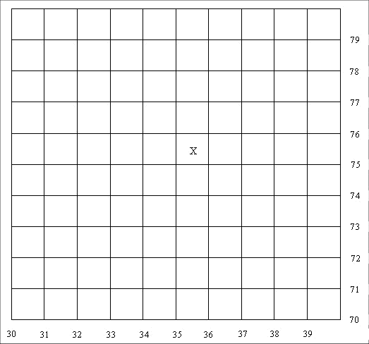
The map margins on the 1:25,000 Ordnance Survey maps are further calibrated into 100-metre divisions, which enables you to imagine the square with the x in it split into 100 smaller squares.
Below is an enlargement of the square ST 3575. To give a more detailed six-figure grid reference, you need to insert a number in the middle of the four-figure grid reference and another one at the end, i.e. ST 35? 75?. If you imagine the lines are numbered in the same way as for the hectad, you can count the lines along the bottom of the square until you reach the line forming the left-hand side of the smaller square containing the x and you come to the number 7. Count the lines up the left-hand side of the square until you come to the line that forms the bottom of the square where the x is and you come to the number 8. A six-figure grid reference for x would therefore be ST 357758.
Further information is provided through Wikipedia.
Tetrads
Tetrads are a popular scale for mapping species. This is an area of 2 x 2 km – a block of four one-kilometre squares. However, it is not possible to translate tetrad data into one-kilometre maps, but it is possible to produce tetrad maps from one-kilometre or better information. For this reason, we prefer all data to be submitted on a one-kilometre or higher scale.
Irish grid references
Irish grid references are based on a very similar system, except that rather than using a two-letter system to denote each 100km square a single letter is used (A-Z). A typical six figure grid reference for, say, county Down would be of the form J234789. Some computer systems which require grid references to be entered with a prefix of two letters insert the letter I (for Ireland or Irish) before the usual grid reference.
Channel Islands – a special case
The grid used on the official maps is the UTM Grid 30 Central Meridian 3 degrees West International Spheroid European datum. Older grid references for the Channel Islands are often given with an alpha prefix for the 100km square (e.g. WV123456 as a 100m grid reference). These references look at first sight like a GB Ordnance Survey standard grid reference, but they are not. The UTM reference does not have the same origin as the GB Ordnance Survey reference. The alpha prefix is not now acceptable and should be converted to the full UTM reference.
When recording the spatial reference use the full UTM format which is preceded by the UTM zone which is 30 in this case. The letters can not be used and the reference must be given in metres. The one metre reference for the south west corner of the Jersey 1:25,000 Official Leisure map is therefore 30 553000 5443000 and that for the Guernsey map 30 523000 5474000. If the 100km letters have been recorded, then these need to be converted to numbers. For example, a Guernsey 100m reference WV231741 becomes 30 523100 5474100 and the 1km reference 30 523000 5474000. For Alderney references WA123987, the conversion is to 30 512300 5598700.
As there is no way to tell the precision from these references, the accuracy of the grid reference should be included in the notes (e.g. accurate to1km, 100m etc.) Users of Recorder 6 should use sample measurement to record this information. Recorder 6 requires the reference in this format - zone, space, easting, space northing's with eastings and northings in metres. (e.g. 30 512300 5598700).