
|
This freshwater meeting investigated the northern branch of the River Wey in east Hampshire, a chalk stream that arises from springs at Will Hall Farm just outside Alton. Further springs augment the flow as it travels north-east to Farnham in Surrey. The river meanders across a wide valley of pasture land below the villages of Holybourne, Froyle and Bentley that are situated on river terrace gravel. Beyond Bentley it crosses into Surrey, flows through Farnham and then abruptly changes direction to the south (an elbow of river capture to geographers) to join the southern branch of the Wey from Haslemere at Tilford. After the confluence the Wey flows to Godalming and Guildford before joining the Thames at Weybridge. After Tilford it is a much deeper river and parts of it have been modified as the Wey Navigation. Some years ago, this society held a field meeting at Tilford and other stations downstream. Although arising on chalk in Alton, from Neatham near Holybourne and eastwards through Froyle the bedrock is Upper Greensand. Further downstream at Bentley the geology is Gault Clay (with numerous tributaries arising off gravels from Alice Holt Forest) and further east towards Farnham the Lower Greensand outcrops as the bedrock. Northern Wey Even close to the source, within the bounds of Alton, this chalk stream is rich in its flora and fauna with a wide range of species coupled with abundance. Several stretches of the river are managed for wild trout fly fishing, including the sites that we visited. Through Bill Stanford of the Baden Powell Fly Fishers (who is also on the committee of the Northern Wey Trust) we had access to a good stretch of private river bank. He kindly joined us for the morning to guide us to the best routes to negotiate fences, gates and river access points. The day of the field meeting was hot and sunny and the ground was very dry so we concentrated our efforts on the freshwater fauna. Eleven members of the Conchological Society were present and also others from the Northern Wey Trust and Alton Natural History Society, a total of 18. In the morning we were in Froyle (figure 1) and took a track opposite the Hen and Chicken to the river and after honing our skills at gate climbing (hinge end!) (figure 2) we worked a stretch of river at SU758422, searching in the weed (Stream Water Crowfoot), flints on the river bed, gravel and silt (figures 3 and 4). Living specimens of the land snails Arianta arbustorum, Cepaea hortensis and Succinea putris were found on the tall vegetation approaching the river whilst we waited our turn to go over the gate. We then followed the river downstream to the bridge behind Shrubbery House (SU459422) where Graham Long took some river gravel samples and Janet Sharpe some leaf litter from the wooded area just across the bridge (on public footpath). Gravel samples were also taken by other members of the group at the main collecting places. Next we took a path at the back of Shrubbery House walled garden where the group divided into two, one searching in a stretch of river, where it was also good to see Marsh Horsetail, and the other crossing a field to “Millenium Bridge” near a pumping station and it was in the latter site that the one living Pisidium amnicum was found by Rosemary Hill (figure 5). Returning to the cars and Hen and Chicken for lunch (see back cover), when the local members left us, we then drove in the direction of Farnham, past Bentley village, to a layby near the Bull Inn and the signposted turning for the Alice Holt Research Station (Forestry Commission). We took this lane as far as the bridge and site of the former Bentley or Turks Mill and followed the public riverside footpath downstream to Holt Pound. Our first collecting and access place was in a meadow before the large meanders (SU/80365 44234), then in a wooded stretch (figure 6) and finally out into another open meadow pasture at SU/80958 44386. The river in these locations was shallow enough to wade in with ordinary Wellington boots and had a range of microhabitats varying in depth, water speed, bottom material and presence or absence of water plants. This is a general feature of the northern Wey in its upper reaches, making it a good river in which to investigate freshwater life. As well as recording living molluscs in situ several of us took shell gravel samples to process later that resulted in some additions to the field list such as Gyraulus (=Armiger) crista and Pisidium species, so worth doing. In the past G. crista has been found in weed washings from the Shrubbery House section. Results are shown in table 1. The total species count was 40, including molluscs from gravel samples and leaf litter. The river habitat produced 29 species, comparing well with the total of 18 for the Alton stretch of the northern Wey. However the more noteworthy species that do not occur in the Alton part of the river, P. amnicum and Unio pictorum, were not in a good state. I have known both of these species in the Wey since 1980 and at that time there was a good living population of P. amnicum in silt under the road bridge arches near Mill Court, just upstream from our first station. In recent years when collecting at Mill Court I have not been able to find them. Likewise the U pictorum shells found in the river opposite the Bull Inn and downstream were in the early 1990s fresher then they are now. On the field meeting we only came across very old eroded shells of single valves and broken fragments and nothing to indicate a living population. In March 1999 a major spill of ammonia from an old ice cream factory that was being cleared on the Mill Lane trading estate in Alton severely polluted the northern Wey from the pollution source in the Caker Stream, just before its confluence with the Wey and extending down river for several miles (Northern Wey Trust Newsletter Nos. 10, 11 and 12). Reports of dead fish in the river led to emergency calls to the Environment Agency who caught the workmen responsible, leading to prosecution. Various parts of the flora and fauna recovered from reservoir populations in the marginal vegetation, with the core of the pollutant being washed down mid-stream, but sensitive species like the larger mussels may not have survived. Unio is distributed by glochidia larvae that attach themselves to the gills and skin of river fish on which they are parasites for the early stages of the life cycle, before dropping off to live a normal bivalve life in the sediment. Infected fish being killed would have been a further set-back for the mussels. We need to work in conjunction with the fly fishers (who take their catch home to eat) to examine the present population of Brown Trout for this stage of the life cycle and also to get into serious wading gear to search suitable deeps where large mussels might still survive, being long-lived animals. Thank you to members of the field meeting for sending additional records. The northern Wey is still a rich chalk stream as a whole, but my impression is that it has suffered from various pollution events – ammonia in 1999, untreated sewage discharge, oils, detergents and heavy metals from road run-off, yeast from the brewery in Alton and more than one spill of silt from building sites on the trading estates along the river. These have led to prosecutions by the Environment Agency through calls to their hotline. Not that this is new as the Wey in Alton has over the centuries been used for discharge from tanneries, dye-houses, privies and paper works. However it supports a chalk stream fly fishery, has a range of different habitats and is worth working to improve its ecological status, for which regular monitoring of the flora and fauna is important. It was this stretch of river valley that Arthur Young (quoted by William Cobbett of Farnham) said was “the best ten miles in England”. The Northern Wey Trust has a series of river wardens (the author being one) who have been regularly checking up on their own section of river over the last 15 years, showing changes in the river, both natural and seasonal, as well as catastrophes. |
figure 1: introductory talk near the Hen & Chickens pub at Froyle. (photo: Peter Topley)
figure 2: Janet Ridout Sharpe tackling the gate.
figure 3: Working the River Wey, Froyle. (photo: Peter Topley)
figure 4: A “pair” of Bithynia tentaculata with freshly laid egg masses, River Wey at SU758422. (photo: Ron Boyce)
figure 5: Live River Wey Pisidium amnicum. (photo: Peter Topley)
figure 6: Collecting in the river near Holt Pound. |
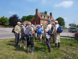
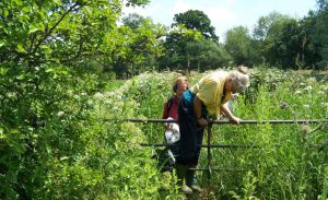
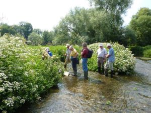
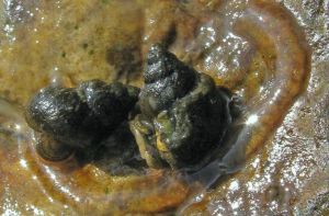
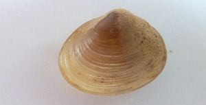
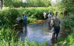
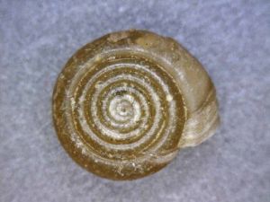
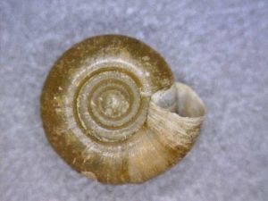
figure 7: Bathyomphalus contortus, River Wey.
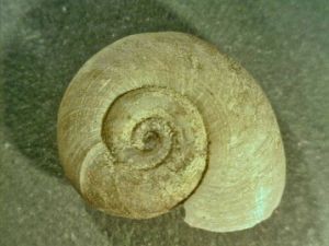
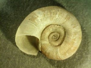
figure 8: Gyraulus albus, River Wey. (photos: Ron Boyce)
| Species | 1 | 2 | 3 | 4 | 5 | 6 | 7 |
|---|---|---|---|---|---|---|---|
| Acroloxus lacustris | S | ||||||
| Aegopinella nitidula | A | S | |||||
| Ancylus fluviatilis | A | A | A | A | |||
| Anisus vortex | A | S | A | A | |||
| Arianta arbustorum | A | A | |||||
| Ashfordia granulata | A | ||||||
| Bathyomphalus contortus | A | S | A | ||||
| Bithynia tentaculata | A | S | A | ||||
| Cepaea hortensis | A | ||||||
| Cochlicopa lubrica | S | A | |||||
| Discus rotundatus | S | ||||||
| Galba truncatula | S | ||||||
| Gyraulus crista | S | S | |||||
| Gyraulus albus | A | A | A | A | |||
| Hippeutis complanatus | |||||||
| Lymnaea palustris | A | S | A | A | |||
| Lymnaea stagnalis | A | S | A | S | |||
| Monacha cantiana | A | ||||||
| Nesovitrea hammonis | S | ||||||
| Oxychilus draparnaldi | A | ||||||
| Oxychilus navarricus | S | ||||||
| Physa fontinalis | S | ||||||
| Pisidium amnicum | A | S | S | ||||
| Pisidium casertanum | S | ||||||
| Pisidium milium | S | ||||||
| Pisidium nitidum | S | ||||||
| Pisidium spp. | A | A | |||||
| Pisidium subtruncatum | S | ||||||
| Planorbarius corneus | S | S | |||||
| Planorbis carinatus | S | S | A | ||||
| Potamopyrgus antipodarum | A | A | A | A | A | ||
| Radix balthica | A | S | S | A | |||
| Sphaerium corneum | S | S | A | S | |||
| Succinea putris | A | ||||||
| Trochulus hispidus | |||||||
| Unio pictorum | S | ||||||
| Vallonia pulchella | S | ||||||
| Valvata cristata | S | S | S | ||||
| Valvata piscinalis | S | A | A | S | |||
| Vitrina pellucida | S | ||||||
| Zonitoides nitidus | S |
table 1: Collecting sites: 1 River Wey and bank from below Hen and Chicken to Shrubbery House Bridge 41/758422; 2 River Wey beyond Shrubbery House 41/76-42; 3 Millenium bridge and pumping station 41/76- 42; 4 Fields opposite Bull Inn 41/80365 44234; 5 Wooded area between 4 and 6; 6 River in field before railway tunnel 41/80958 44388; 7 Leaf litter samples in wooded slope behind Shrubbery House bridge 41/759425.
Key: S = shell only A = alive. (Janet Ridout Sharpe and June Chatfield)