
There is a wealth of records for the non-marine mollusca of Ireland due to the great efforts of amateur and professional conchologists and malacologists for the last two centuries. Much of these records have been held and maintained by the Conchological Society of Britain and Ireland in paper formats. However, there are many records held in other mediums by different groups and individuals within the island of Ireland, including the National Parks and Wildlife Service (NPWS), the Heritage Council, the Centre for Environmental Data and Recording (CEDaR) and other published and unpublished records. A project was undertaken in Ireland to digitise and capture as much data as possible on this group, populate a database with these data and dynamically display the results online via a mapping system. This is the first time in Ireland that all the data on this group will be centralised and data managed as a unit. It also is a very important digital repository for records; a ‘bank’ in which records are stored and safeguarded for future generations.
Data has been sourced, digitised and data cleaned over the period since December 2007. The dataset was uploaded on the mapping system on 20/01/2009 [Note: Not all data has been displayed on the mapping system thus far: Margaritifera sp. records have been omitted due to their sensitive nature. Species with new taxonomic nomenclature and certain aggregate groups are also not currently displayed, but will be in the near future]. There are 149 species of mollusc mapped, from 2,446 sites, with a total of 46,615 records that range in date from 1842 to 2007. The database can be interrogated through the National Biodiversity Data Centre’s online mapping system (maps.biodiversityireland.ie). The database is currently on a beta test; permitting the database to be accessed online in a testing phase allowing validation and feedback from experts and end-users (users comments are welcome).
Demonstration of viewing molluscan data using the mapping system Images of the mapping system are shown here to demonstrate the functionality of this system for displaying and interpreting molluscan data. Firstly the database was queried for two species of conservation interest, Myxas glutinosa and Pisidium moitessierianum, both of which appear on conservation assessments for Ireland (Bratton, 1991 in Kerney, 1999; Moorkens, 2006). Myxas glutinosa has had widespread losses across its range in Northern Europe with documented population extinctions (Kerney, 1999; Bouchet et al., 1999). Pisidium moitessierianum was considered extinct in Ireland (Kerney, 1999) until it’s rediscovery in 2003 in the Royal Canal (Killeen and Moorkens, 2003). It has been considered endangered in Ireland and is in decline across much of its native range (Moorkens, 2006). The distributions for each of the species were mapped together, using the online mapping system on the island of Ireland scale (Figure 1). The midlands-east region of Ireland is focused on for the purposes of this demonstration. The mapping system allows one to view records against different GIS (Geographic Information System) layers (for example, localities, designated areas etc.), in this case the records are viewed against the counties of Ireland layer (Figure 1).
The ‘zoom in’ tool was then used to view the records in the 1km square that the two species co-occured. Some records had high resolution (100m or higher) and so the mapping system displayed the records at this resolution. At these higher resolutions the Discovery Series Ordnance Survey layer cuts in, showing that the records are actually from around Kilmore Bridge, Co. Kildare (Figure 2). Zooming further in reveals the aerial photograph layer of the site. Due to the fact these species are considered rare and endangered in Ireland, it was queried to see if the area was protected in anyway (Figure 2). The records were, at least, partially in proposed Natural Heritage Areas (pNHAs), though it is possible that the species may have been recorded just outside of the protected boundary.
We hope this resource will be used by (and useful for) recorders and encourage, and enthuse, people to study and be interested in this important part of Ireland’s fauna. We also hope that the database, as a repository, will be utilised as a safeguard of valuable biological information for generations to come.
Acknowledgements
We would like to thank the funders of this project, National Parks and Wildlife Service and the Heritage Council. We also would like to thank key collaborators: the Conchological Society of Britain and Ireland, Centre for Environmental Data and Recording (CEDaR) and all the recorders of the non-marine mollusca of Ireland, without their work this resource would not exist.
References
Bouchet, P., Falkner, G. and Seddon, M.B. (1999). Lists of protected land and freshwater molluscs in the Bern Convention and European Habitats Directive: are they relevant to conservation? Biol. Cons., 90 (1) 21- 31.
Bratton, J.H. (editor) (1991). British Red Data Books: 3. Invertebrates other than insects. JNCC. Killeen, I.J. and Moorkens, E.A. (2003). Pisidium moitessierianum Paladilhe, 1866, rediscovered in Ireland. J. of Conch. 38: 94. Kerney, M. (1999). Atlas of the land and freshwater molluscs of Britain and Ireland. Colchester, Harley Books.
Moorkens, E.A. (2006). Irish nonmarine molluscs – an evaluation of species threat status. Bull. of the Irish Biogeog. Soc. 30, 348-371.
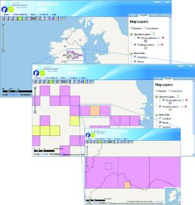
Figure 1: The distribution of the 51 records for Myxas glutinosa and the 16 records of Pisidium moitessierianum. At low resolutions the records are shown as 10km squares. At higher resolutions the records are shown either at 1km square or the level at which the record was taken. Purple = M. glutinosa yellow = P. moitessierianum orange = both species.
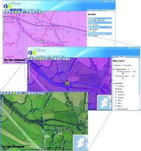
Figure 2: The distribution of the records for Myxas glutinosa and Pisidium moitessierianum from Kilmore Bridge at 100m resolution. Both species co-occur at the same site and they are selected in the first view. The NHA GIS layer is selected in the second view. Turning off the species layers allows the end-user to view the site’s aerial photograph alone (third view). Blue/yellow = cooccurrence of species.