
Issue
18
Page
22
|
As the Isle of Wight meeting was taking place on a Sunday, we thought it might be a good idea to save ourselves from too early a start from home and have a leisurely field trip in the New Forest on the Saturday. The weather, however, had other ideas, so instead we settled for seriously under-cover activities in deepest Dorset and booked into a B&B in Lymington in the early evening.
In the morning the heavy rain had stopped and we joined the group tour minibus at the ferry terminal. This was very useful as we then counted as minibus passengers and could travel at very advantageous rates. The places in the minibus were organised for us by Mike Weideli, to whom we are very grateful. The trip did not prove very easy for Mike, who had his leg in plaster after having sustained very serious damage to his ankle while doing the preliminary survey for this trip on 20 February. The injury resulted in an operation and a week’s stay in Newport hospital.
The minibus group met up in the car park at Yarmouth with the other participants in the excursion, 22 of us all told.
The meeting itself consisted of a geological tour of the southwest coast of the Isle of Wight organised by the Newbury Geology Society and ably led by Dr Leslie James of the University of Reading. The excursion was designed to give an introduction as to how basic geological stratigraphy relates to what can be seen on the ground. This particular region of the Isle of Wight is arguably one of the best places on earth to learn how to recognise geological strata visually, as a very wide selection of layers are visible simultaneously. There has been very pronounced tilting of the earth’s crust in this area and many of the strata are exposed almost vertically so that it is possible to walk along the beach and view the layers end-on, travelling backwards in time through a million or so years in the space of a few footsteps. By viewing the various layers in this way you can easily learn what they look like, and this can be very helpful when exploring the remainder of the island. The range of strata here stretches from the Wealden Beds of the Lower Cretaceous 130 million years ago at Brighstone Bay all the way up to the Headon Beds at Colwell Bay and Totland Bay about 35 million years ago.
We began our journey back in time with the Headon Beds in Colwell Bay. There are good exposures here and we collected quite a range of fossil shells including Ostrea velata, Potamides vagans, Globularia grossa, Pitar sp, Corbicula obovata, Theodoxus concavus, Discus rotundatus [surprising what can creep into a fossil deposit when nobody is looking!], Euthriofusus sp, Batillaria sp and another species I had not seen before, so far provisionally identified as Bonnellitia sp (Cancellariidae), with spiral ridges on the columella [pictured]. A considerable length of the bay here has been reinforced using a metal barrier and huge blocks of imported rock to guard against wave erosion.
We then visited Alum Bay with its spectacularly coloured sand and clay strata. As an area for collecting fossil Mollusca this proved a great disappointment because the entire base of the cliff had been cordoned off using conventional road works barriers festooned with tape inscribed with messages forbidding us to cross. This, however, did not interfere significantly with taking photographs of these beautiful cliff faces provided we were careful.
Our next port of call was the Dinosaur Farm museum {SU441810] at Brighstone about ten miles eastwards along the coast (marked as Sutton Farm on the map).
The museum contained a good example of shell-bearing strata and a range of ammonites showing various degrees of uncoiling including the improbably-shaped Deshayesites, in which the usual cephalopod system of jet propulsion could not have worked. It has been suggested that none of the ammonites used this technique and that they all operated by crawling along the sea bed with their shells supported by an air bubble. The exhibit in the museum postulating what a live one looked like would then presumably refer to a newly dead specimen.
We then went back along the military road to Hanover Point. We did not manage to see the Wealden Beds here as these are below the chalk and are exposed only at low tide. Near the top of the cliff, however, were exposures of subfossil timber in an old river bed laid down when the Isle of Wight was still part of the mainland. Further east, at Freshwater Bay, we saw signs of another river bed, and were shown where the military road had run in the early nineteenth century. A large section of the original road around Freshwater Bay has been lost to the sea. A further section of the road in the direction of Ventnor has recently been rendered unusable through coastal erosion and a debate is still going on as to where the replacement section should be sited.
Our thanks are due to Newbury Geology Society for arranging this very interesting trip.
|
Photo captions (all photos Ron Boyce)
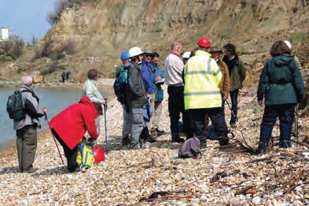 Figure 1: Newbury Geology Society at Colwell Bay
 Figure 2: Bonnellitia sp (Cancellariidae), length 9 mm, from the Headon Beds at Colwell Bay
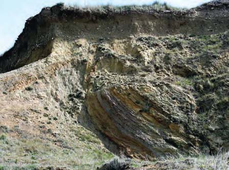 Figure 3: Upended Eocene strata in Colwell Bay with level ones above them
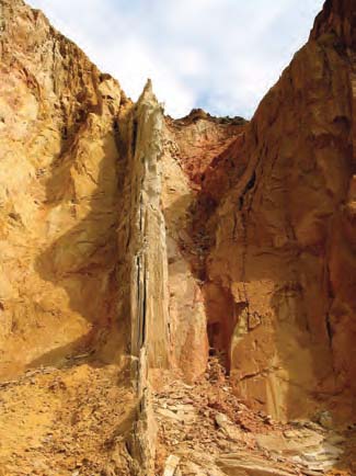 Figure 4: Vertical strata in Alum Bay
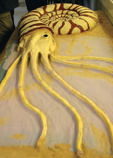 Figure 5: Model ammonite in the Dinosaur Farm Museum showing what the living animal may have looked like
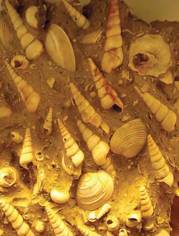 Figure 6: Molluscan fossil deposit in the Dinosaur Farm Museum
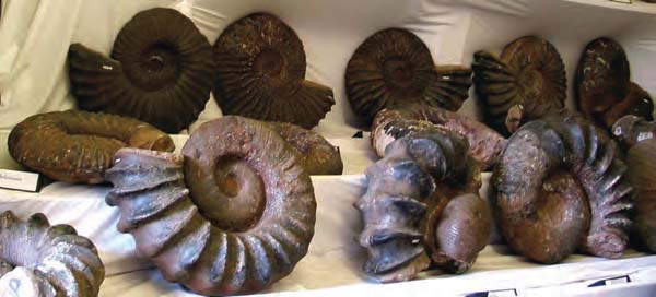 Figure 7: Conventional ammonites in the Dinosaur Farm Museum
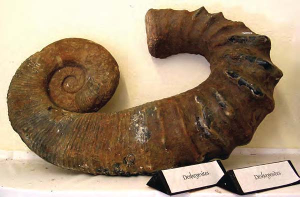 Figure 8: Uncoiled ammonite Deshayesites in the Dinosaur Farm Museum
|